|
IvAcCapture a Sectorfiles Design Utility |
-
IvAcCapture to create special drawings in Sectorfiles and more ... Rel.1.0.5.0 Screenshots
Download 1358 Kb. Rel.1.0.5.0 (25/Aug/11)
-
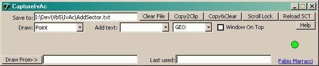
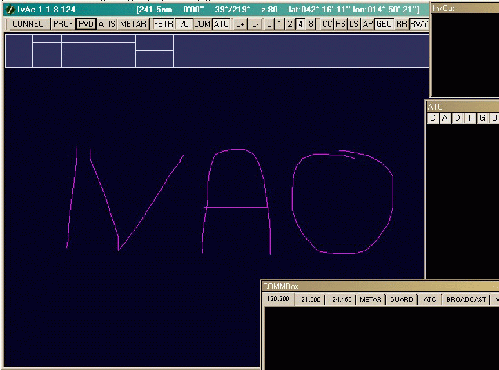
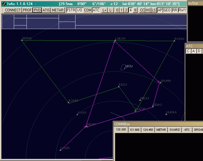
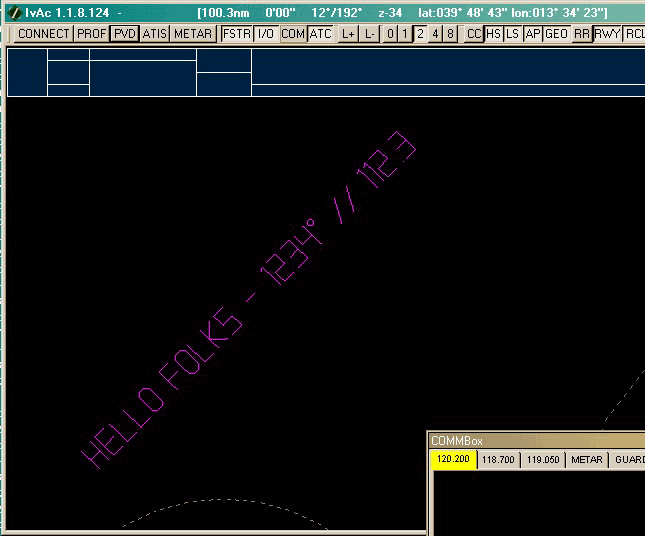
IvAcCapture is a small utility that can be used in IvAc sector design.
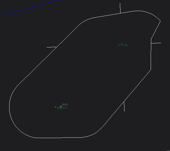
It's able to generate points, lines or complex drawing in .SCT format.
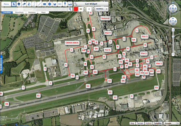
It's also capable to "capture" IvAc Title Bar window Lat/Long coordinates
This feature enable you to "draw" directly form IvAc window.
Each figure (or point/line) can be used in [GEO],[SID], STAR], [ARTCC], [ARTCC LOW] and [ARTCC HIGH] sections of .SCT file
For each section you can specify the line type ([GEO]) or the name ([STAR]/[SID])
All drawings are written in a temp file and at any time can be copied to the clipboard and manually pasted to the .SCT file.
A reload button refresh current sector in IvAc (no current view restore available - sorry)
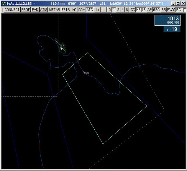
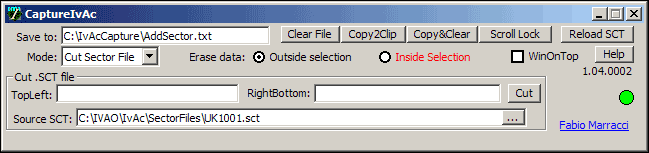
A function to cut a delimited Section of a .SCT file selecting rectangle coordinates from IvAc window is also available
Of course you can also cut OFF a delimited Section of a .SCT file selecting rectangle coordinates from IvAc window
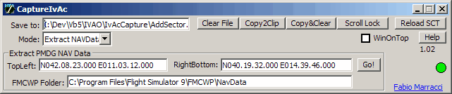
You can also use IvAcCapture to extract VOR/NDB/FIX/AIRWAY from NavData files (PMDG version) into .SCT file selecting a rectangular or circular area (specifiy topLeft/BottomRight coordinates or Center/range in NM
For repetitive tasks is available a CommandLine option to specify a file containing the tasks to perform
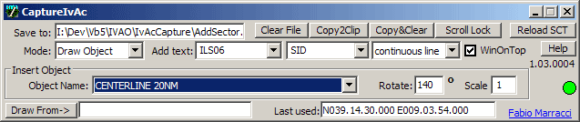
Draw own defined objects (using the Object SDK examples) with custom rotation and scale
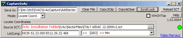
Locate coordinates in the SCT files; click on IvAc window and you'll get the nearest point defined in the Sectorfile
(nearest coordinates for each section)
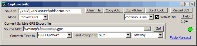
Convert ScribbleMaps GPX Export files (text and lines only) to standard sectorfile format
New Upgraded standard font (STANDARD.CFF)
New Added new objects: Circle, VRP Sign
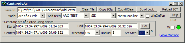
New Added new drawing function: Arc of a Circle - design a circle between two coordinates using a centerpoint
New It's now possible to enter coordinates in ddmmssN dddmmssW format (Eg.531855N 0031647W)
Remember: you can create your own font or object using the FONT SDK and OBJECT SDK
-
Usage:
Launch IvAcCapture
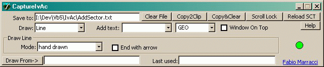
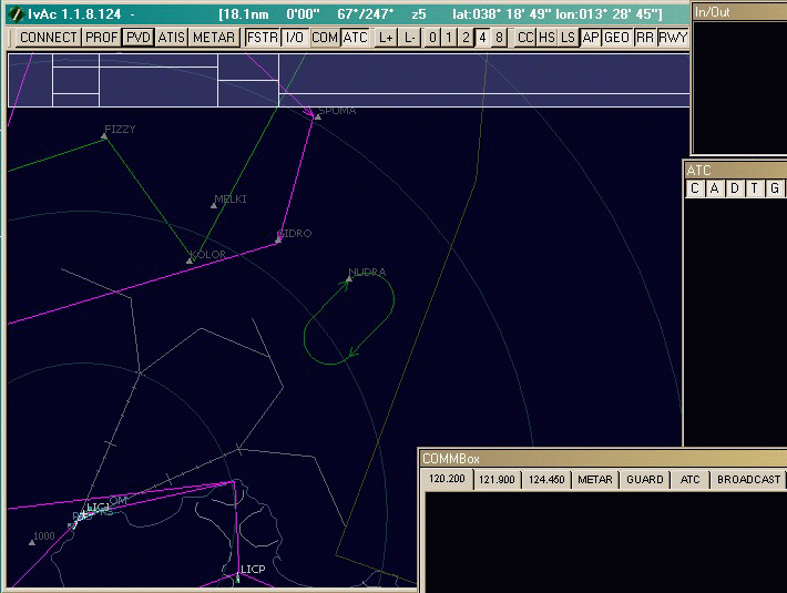
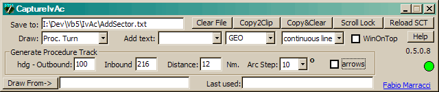
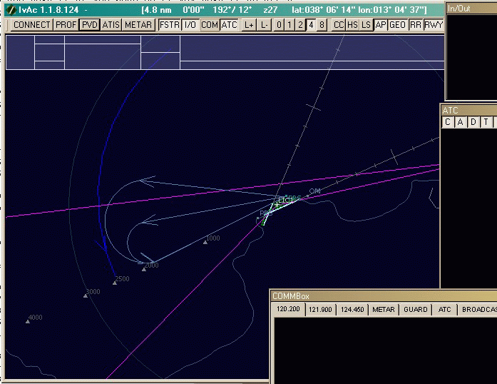
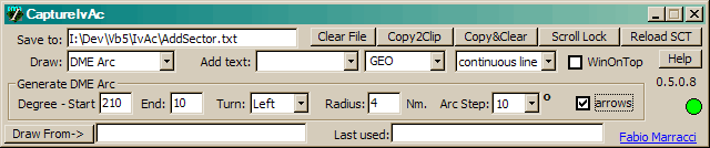
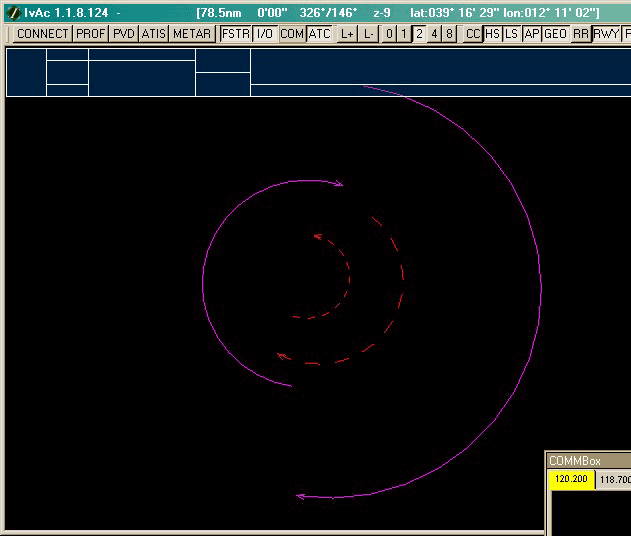
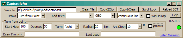
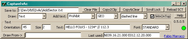
Choose figure to draw (point, line, holding, Procedure turn, DME arc, Turns, Text) and set right parameters
Check the WindowOnTop flag
Change to IvAc window (ALT+TAB)
Turn on Scroll-Lock key to enable recording
Click directly on IvAc window the starting point of the figure
If the figure is a complex design as Holding, Procedure Turn, DME Arc, Turns or Text, the Scroll-lock will be turned off automatically
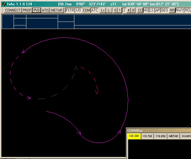
Otherwise, continue single click to draw all lines (or points) you need
If you need to move the IvAc Map, keep ALT key button pressed while moving or zooming, then release and continue clicking to draw.
If you need to draw an "handfree" line, use the Mouse Center button (or Mouse Wheel button) instead of Mouse Left button.
Once finished, turn Scroll-lock Off
Use the Copy&Clear button to copy your draw to the clipboard and manually paste it into your .SCT file.
Use Reload button to reload PDV into IvAc
Note: full remarks in the temp file
-
Limitations
Tested only on Windows XP - SP2
Error on coordinates 1 degree west of Greenwich Meridien (IvAc Bug)
requires VB5 Runtime
requires Microsoft XML 3 Parser for ScribbleMaps convertions
Not tested near Equatorial and Polar region
When cutting Sector Files, the Save to filename is used as output
for bugs or suggestions feel free to e-mail to
-
Change Log
1.0.5.0 — 25/Aug/11 — Added function to force West coordinates when drawing near Greenwich Meridian
(IvAc 1 degree Long bug)1.0.4.7 — 01/Aug/11 — Added new objects - VRP point and Circle 1.0.4.6 — 01/Jun/11 — Added function to draw Arc of a Circle using Center/Start/Stop 1.0.4.5 — 20/Mar/11 — Upgraded numbers on Standard font 1.0.4.4 — 07/Oct/10 — Corrected bug on Cutting Sector Inside Selection (AIRWAYS and Airspaces) 1.0.4.3 — 28/Sep/10 — Added option to erase sector section in Cut Sector function 1.0.4.2 — 30/Aug/10 — Small bug on Cut sector corrected 1.0.4.1 — 30/Aug/10 — Reload Sector fully functional (no need to press "Open" button) 1.0.4.0 — 20/Aug/10 — Added function to convert ScribbleMaps GPX export files 1.0.3.8 — 17/Feb/10 — Corrected window size (Vista/Seven) 1.0.3.7 — 10/Dec/09 — Corrected bug on Navdata circular extraction (Error '5') 1.0.3.6 — 09/Dec/09 — Improvement and correction in Navdata extraction 1.0.3.5 — 01/Dec/09 — Corrected some bugs on Navdata circular extraction 1.0.3.0 — 27/Nov/09 — Added function to Draw own defined objects (with custom rotation and scale)
Added function to search Coordinates in SCT file1.0.2.0 — 20/Aug/09 — Extract NavData info (VOR/ILS/NDB/FIX/AIRWAY) to .SCT file 1.0.1.1 — 24/Jan/09 — Corrected bug drawing dashed/dotdashed lines 1.0.1.0 — 10/Dec/08 — Added ARTCC drawings 1.0.0.8 — 17/May/08 — Added DashedDotLine function 1.0.0.7 — 10/May/08 — Added file script interpreter 1.0.0.6 — 01/Jan/08 — new version numbering - some bugs correction 0.5.0.9 — 12/Jun/07 — Corrected display bug on Cut Sector function 0.5.0.8 — 20/Dec/06 — Arrows becames optional in some figures 0.5.0.7 — 05/Aug/06 — Added Cut Sector function 0.5.0.6 — 26/Jun/06 — Corrected Bug on Text function 0.5.0.5 — 23/Jun/06 — added Text writing function
IvAcCapture.ini for dashed-line settings0.5.0.4 — 08/May/06 — added Turn from Point function 0.5.0.3 — 07/May/06 — added Line Type (continuous or dashed-line) on drawing 0.5.0.2 — 30/May/06 — bug regarding negative Longitude should be fixed
-
Screenshots click on the following buttons to display features
Draw single point